Life-threatening flash flood emergencies are sweeping across parts of the South on June 20, 2026, as the remnants of Tropical Storm Arthur dump catastrophic rainfall across the region. Fox Weather, which is tracking the storm in a live updates blog, reports that the National Weather Service has issued some of its most severe possible alerts — flash flood emergencies — for multiple communities facing rapidly rising waters.
The non-obvious detail most headlines are skipping: a flash flood emergency is not the same as a standard flash flood watch or warning. The NWS issues this rare, highest-tier alert only when a flash flood poses an imminent threat to human life and catastrophic damage is already occurring or is imminent. Communities in the affected zone should treat it as a signal to move to higher ground immediately — not to shelter in place.
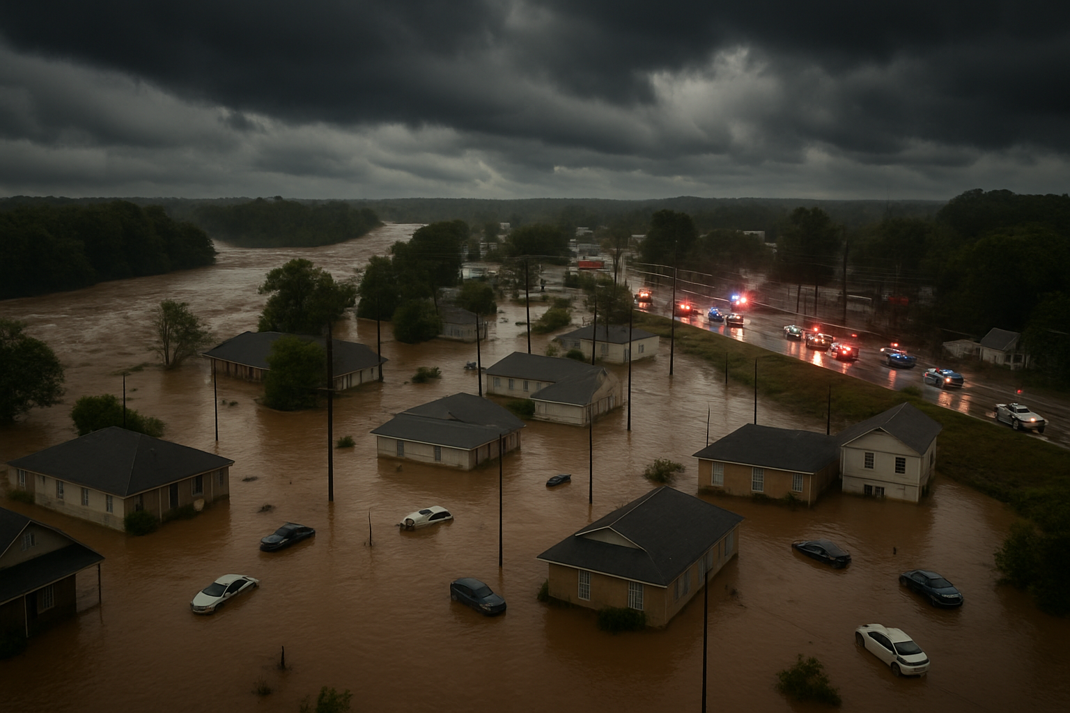
Where the Flash Flood Emergency Zones Are Hitting Hardest
Arthur’s remnants have been funneling deep tropical moisture northward into the South, overwhelming drainage systems and river basins already saturated from earlier spring rainfall. Rainfall rates in the hardest-hit corridors have reportedly reached several inches per hour in short bursts — the kind of intensity that can turn a dry road into an impassable torrent in minutes.
Localized flooding has been reported across roadways, low-lying neighborhoods, and underpasses. Residents in affected areas have been urged by emergency managers to avoid all travel through flooded roads, following the well-worn but often ignored rule: turn around, don’t drown. Floodwaters as shallow as six inches can knock a person off their feet; just two feet of moving water can carry away most vehicles.
River gauges across several Southern waterways are surging toward or past flood stage, raising concerns that the flooding threat will persist well beyond the initial rainfall event. Flash flooding can linger for hours after rain stops, especially near rivers and streams that peak on a delay.
What Made Arthur’s Remnants So Dangerous
Tropical Storm Arthur formed early in the 2026 Atlantic hurricane season and tracked in a way that positioned its moisture-laden remnants directly over terrain vulnerable to rapid runoff. Unlike a landfalling hurricane, a tropical system’s remnants can stall or meander, wringing out enormous rainfall totals over a tight geographic area for an extended period.
The combination of tropical-origin moisture — which carries far more water vapor than a typical mid-latitude storm — and slow movement is a recipe for catastrophic flooding. Meteorologists refer to this as a “training” rain pattern, where successive bands of storms repeatedly cross the same area like boxcars on a train track.
The event follows a broader pattern of increasingly intense rainfall episodes across the U.S. South in recent years, as warmer Gulf of Mexico sea surface temperatures provide more fuel for moisture-laden systems. This season’s early activity has already put forecasters on high alert heading into the peak of Atlantic hurricane season.
Safety Steps If You’re in an Affected Area
- Do not drive through flooded roads. The depth of water is impossible to judge visually, and road surfaces beneath floodwaters may have already washed away.
- Move to higher ground now if you are in a flash flood emergency zone — do not wait for official evacuation orders.
- Avoid walking through moving water. Six inches of fast-moving water is enough to knock an adult off their feet.
- Stay off bridges over rapidly flowing streams and rivers, which can overtop with little warning.
- Monitor the NWS and local emergency alerts continuously, as conditions can change within minutes during active flash flood emergencies.
The Broader Severe Weather Picture
This flash flood emergency comes during an already active severe weather stretch for the South and Midwest. Earlier this week, significant storm systems caused widespread damage across parts of Illinois — as storms in the Effingham area caused significant damage Wednesday night, a reminder of how relentless the 2026 severe weather season has been for central and southern U.S. communities.
Emergency management officials across the affected Southern states are coordinating swift-water rescue teams and pre-positioning resources in anticipation of residents needing evacuation from flooded homes. First responders have issued public pleas for residents not to call for help due to curiosity or minor flooding, keeping emergency lines available for life-threatening situations.
Flood-related deaths in the U.S. account for more weather fatalities than any other hazard in most years, and the majority involve people attempting to drive through floodwaters. Officials are emphasizing that point repeatedly as this event unfolds.
What Comes Next
The flash flood threat is expected to gradually diminish as Arthur’s remnant moisture disperses, but river flooding may continue to rise for 12 to 24 hours or more after the heaviest rain ends. Communities downstream from areas that received the most rainfall face a secondary flood threat as water drains through the river system.
The National Weather Service will continue issuing updated flash flood watches, warnings, and emergencies as conditions evolve. Residents across the South are advised to check local NWS forecast offices for the latest information specific to their county and to sign up for Wireless Emergency Alerts, which will push life-safety notifications directly to mobile phones without any app required.
As of June 20, 2026, the full scope of damage and any casualties from the flooding are still being assessed. NarwhalTV will update this story as new information becomes available.