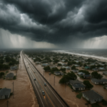
Potential Tropical Cyclone One is drenching the Texas Gulf Coast with dangerous rainfall in June 2026, according to Yale Climate Connections, which is tracking the system closely as it edges toward land. The system had not yet met the wind-speed threshold for a named tropical storm as of the latest updates — but that technical distinction offers little comfort to communities already dealing with Texas coast flooding.
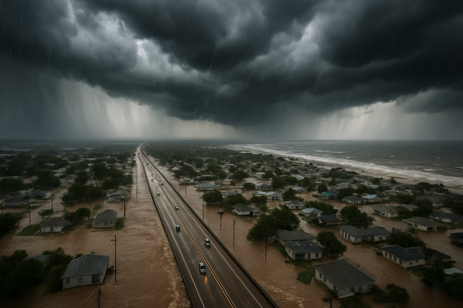
Here’s the detail that stands out most: a system does not need to be a fully organized tropical storm to produce catastrophic rainfall. Potential Tropical Cyclone One is delivering flooding rainfall totals while its core circulation is still organizing — meaning the worst wind and surge threat may still be ahead, even as neighborhoods are already underwater.
What Forecasters Are Saying About Tropical Cyclone One
The National Hurricane Center has been issuing advisories on the system, flagging the risk of flash flooding and storm surge along a stretch of the Texas coast from Corpus Christi northward toward the Houston metro area. Forecasters warn that slow forward motion is a key danger factor. The slower a system moves, the more rain it dumps on the same locations — and early track models suggest this one is in no rush.
Storm surge is a separate but equally serious threat. Even a modest, disorganized system can push a wall of seawater inland along low-lying coastal areas, especially in communities that sit at or near sea level. Parts of the Texas Gulf Coast fit that profile almost perfectly.
Texas Coast Flooding: Who Faces the Greatest Risk
The highest-impact zones are coastal counties with significant flood-prone infrastructure — think Galveston Island, Brazoria County, and the areas south of Houston. These communities have dealt with repeated hurricane hits over the past decade, and flood fatigue is real. Many residents have rebuilt once or twice already.
Inland flooding is also a major concern this time. Heavy rainfall bands can extend far from the center of a tropical system, pushing rivers and bayous over their banks well inland. Harris County — home to Houston — has world-class flood monitoring infrastructure built after Hurricane Harvey, but even that system has limits when rainfall totals climb into double digits in 24 hours.
- Storm surge: Coastal areas could see several feet of inundation depending on the final track.
- Flash flooding: Rainfall rates may exceed what local drainage systems can handle.
- Rip currents: Dangerous conditions are expected along Gulf beaches even far from the storm’s center.
- Tornadoes: Tropical systems often spawn brief, hard-to-predict tornadoes as they make landfall.
Hurricane Season 2026: An Early Start
The Atlantic hurricane season 2026 officially began June 1, and Potential Tropical Cyclone One is an early indication that this season means business. Climate scientists have pointed to elevated Gulf of Mexico sea surface temperatures as a factor that could support more intense and wetter storms this year. Warmer water fuels storm development and increases the moisture a system can carry — translating directly into heavier rainfall totals.
The Gulf has recorded persistently above-average sea surface temperatures heading into peak season, which runs from mid-August through October. A system forming in June already taps into that warm reservoir, and forecasters say it’s a pattern worth watching carefully for the months ahead.
For a broader view of how data and technology are shaping responses to extreme weather threats, see how French intelligence agencies are rethinking their reliance on U.S. data platforms — a debate with implications for emergency-response systems worldwide.
What Residents Should Do Right Now
Texas emergency management officials are urging coastal residents to act before conditions deteriorate, not after. The standard advice carries real weight here: never drive through flooded roadways. More people die in flooding events from driving into standing water than from any other flood-related cause.
Residents in low-lying or evacuation zones should:
- Monitor the National Hurricane Center’s latest advisories and local emergency alerts.
- Have a go-bag ready with medications, documents, and three days of supplies.
- Know your evacuation route — and a backup route if primary roads are already flooded.
- Move vehicles, outdoor furniture, and valuables to higher ground now.
People outside the immediate coastal zone shouldn’t tune out. Tropical rainfall bands have already been pushing well inland, and rivers across South Texas can rise quickly even when skies look clear locally.
What Happens Next
The key question over the next 24 to 48 hours is whether Potential Tropical Cyclone One organizes into a named tropical storm before — or after — it makes landfall. If it intensifies offshore, the wind and surge threat escalates sharply. If it stays disorganized but slow-moving, the primary threat remains catastrophic rainfall and inland flooding.
Either way, the Texas coast is already feeling the impact. With hurricane season 2026 barely two weeks old, this system is a loud early signal that preparation — not just response — saves lives. Track the latest storm surge and rainfall forecasts directly from the National Hurricane Center, which updates advisories every six hours as the system evolves.
And if you’re interested in other major stories unfolding this week, check out NarwhalTV’s coverage of the NO FAKES Act and the fight over AI-generated likenesses — another story with real consequences for everyday Americans.